BackStaff
Around 1590, English seaman and explorer John Davis wrought a revolution in celestial navigation by inventing the backstaff. This new tool was so simple and so practical that it remained in use for more than 200 years and sailors were so grateful that the Davis Strait, between Baffin Island and Greenland, was named in John Davis' honor.
The backstaff itself was actually an improvement on the design of the cross-staff. The backstaff improved on it's predecessor by eliminated the frequent parallax errors (mistakes in calculation resulting from taking sightings from objects in irregular orbital patterns). In addition, there was no glare to contend with because the user stood facing away from the sun (hence the name).
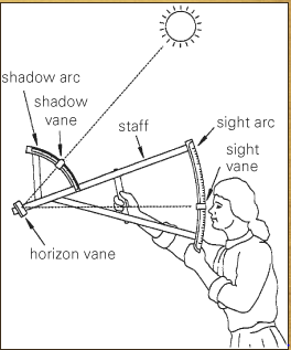
The backstaff consisted of three vanes (a sight vane, a shadow vane, and a horizon vane) and a pair of wooden arcs attached to a staff. Davis’s invention was as significant an advance in his time as GPS has been in ours: the back-staff made it possible to read the altitude of the sun and moon in minutes rather than degrees so, for the first time, navigators could consistently find their latitude to within a few miles.The backstaff was later fitted with mirrors so it could be used for star and planet sights as well. [1]
The following video gives instructions on how to use a backstaff:
The backstaff itself was actually an improvement on the design of the cross-staff. The backstaff improved on it's predecessor by eliminated the frequent parallax errors (mistakes in calculation resulting from taking sightings from objects in irregular orbital patterns). In addition, there was no glare to contend with because the user stood facing away from the sun (hence the name).
The backstaff consisted of three vanes (a sight vane, a shadow vane, and a horizon vane) and a pair of wooden arcs attached to a staff. Davis’s invention was as significant an advance in his time as GPS has been in ours: the back-staff made it possible to read the altitude of the sun and moon in minutes rather than degrees so, for the first time, navigators could consistently find their latitude to within a few miles.The backstaff was later fitted with mirrors so it could be used for star and planet sights as well. [1]
The following video gives instructions on how to use a backstaff:
Octant
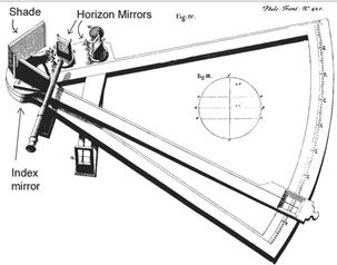
Octant is a reflecting instrument using mirrors to reflect the path of light to the observer and, in doing so, doubles the angle measured. The octant provided a number of advantages over previous instruments.
The sight was easy to align because the horizon and the star seem to move together as the ship pitched and rolled. This also created a situation where the error in observation was less dependent on the observer, as he could directly see both objects at once.
With the use of the manufacturing techniques available in the 18th century, the instruments were capable of reading very accurately. The size of the instruments was reduced with no loss of accuracy. An octant could be half the size of a Davis quadrant with no increase in error.
Using shades over the light paths, one could observe the sun directly, while moving the shades out of the light path allowed the navigator to observe faint stars. This made the instrument usable both night and day.
By 1780, the octant and sextant had almost completely eliminated all previous instruments. [2]
The following video illustrates how to use an octant:
Quadrant
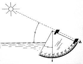
The quadrant received its name because it is one-fourth of a full circle. In fact, quad means "four". It had much use even before it went to sea to help navigators. Originally Astrologers would use the quadrant to help determine an eclipse of the sun or to forecast someone's fate with help from the stars. It was simply a device for measuring the angular height of a star or the sun. Surveyors could use it to measure the height of a building or a mountain. It was even used to help aim a cannon to hit an enemy fortress.
For the sailor, it was first used to measure the height of Polaris, the Pole star. While the earliest documented (written) use of the quadrant at sea is in the mid 1400s, it was in use well before that by astrologers and land-surveyors. It became important to Europeans when the Age of Exploration began in the early 1400s. It was common knowledge at the time that the pole star moved very little at night due it's position above the North Pole. They knew it wasn't exactly at the North Pole, but pretty close. In fact it's about one degree away from being exactly at the North Pole today, and was about 3 1/2 degrees off in the time of Christopher Columbus. People knew these things, but didn't have any practical use for the information ashore.
Sailors had learned from the Arabs that the Pole Star could also help with navigation; the height of Polaris above the horizon changed depending on a person's Latitude, the distance above or below the equator. Knowing how high Polaris was at a particular port city you wanted to reach would help you navigate your way there.
Of course, one of the problems with Polaris is that it disappears if you travel below the equator. The solution was to then navigate using the sun to determine latitude. [3]
The following video demonstrates how to use a quadrant:
References
[1] www.thepirateking.com/historical/backstaff.htm
[2] en.wikipedia.org/wiki/Octant_(instrument)
[3] http://www.thepirateking.com/historical/quadrant.htm
[2] en.wikipedia.org/wiki/Octant_(instrument)
[3] http://www.thepirateking.com/historical/quadrant.htm

 RSS Feed