At a time when the earth was presumed to be flat, terrifying monsters supposedly inhabited the seas and Mediterranean sailors were content to stay in familiar waters. Some courageous mariners set sail for uncharted territory. Some were intrepid explorers in search of new trade routes. Others, confident that tales of mysterious lands far past the horizon were true, were determined to go there – and return. [1]
Following the light of the sun, we left the Old World. | The history of navigation is the history of seamanship, the art of directing vessels upon the open sea through the establishment of its position and course by means of traditional practice, geometry, astronomy, or special instruments [2] |
The first record of boats large enough to carry goods for trade is around 3500 B.C. and this would mark the birth of the art of navigation.These first navigators stayed close to shore and navigated by sight of landmarks or land characteristics that they could see. Usually they traveled by day and sought a calm harbor or anchorage at night. They did not have charts but lists of directions, similar to today’s cruising guides
| The first ocean voyages were probably big mistakes – a vessel blown off course by a sudden storm or error by the helmsman. The Vikings regularly sailed to Iceland and Greenland between 900 and 1000 AD, apparently using only the sun, stars and wind as their guide. As brave as these early navigators must have been, they were also creative in compensating for their lack of technology. Floki Vilgjerdarsson, a great Viking explorer credited with the discovery of Iceland, carried aboard a cage of ravens. When he thought land should be near, he would release one of the birds. If it circled the boat without purpose, land was not near, but if it took off in a certain direction, the boat followed, knowing the bird was headed toward land. [3] | 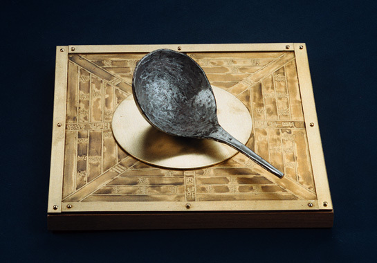 Chinese were the first to invent Compass. The initial crude compass consisted of a magnetised lodestone |
Early mariners plotted their course by observing major constellations, though this was not an exact science. Estimates of distance travelled were made based upon multiplying the time underway by the speed of the vessel. Since time was measured with a sandglass and speed was estimated by watching pieces of seaweed pass by the hull, these early calculations were often less than accurate.
One of the earliest man-made navigation tools was the mariner’s compass, which was invented by the Chinese in the twelfth century though the first versions were very crude. The navigator would rub an iron needle against a lodestone, place it in a piece of straw, and float it in a bowl of water. The needle would point in a northerly direction. Early mariners found the compass inconsistent – most likely because they did not understand that it pointed to the magnetic north pole, not true north.
One of the earliest man-made navigation tools was the mariner’s compass, which was invented by the Chinese in the twelfth century though the first versions were very crude. The navigator would rub an iron needle against a lodestone, place it in a piece of straw, and float it in a bowl of water. The needle would point in a northerly direction. Early mariners found the compass inconsistent – most likely because they did not understand that it pointed to the magnetic north pole, not true north.
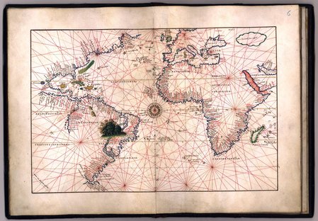 A portolan Chart made in the 13th Century | After mariners began to keep detailed records of their voyages, land-based mapmakers used these sailing directions to create the first nautical charts called Portolan Charts (c. 13th Century). The charts were rare and very expensive, often kept secret so that competing mariners would not have access to this knowledge. The charts did not have latitude or longitude lines but did have compass roses indicating bearings between major ports. |
A major advance was the invention of the chip log (c.1500-1600). Essentially a crude speedometer, a line was knotted at regular intervals and weighted to drag in the water. It was tossed overboard at the stern as the pilot counted the knots that were let out during a specific period of time. From this he could determine the speed the vessel was moving. Interestingly, the chip log has long been replaced by equipment that is more advanced but we still refer to speed on the water as “knots.”
The key to determining longitude, or how far east or west they were located, lay in the invention of an accurate time-keeping device. Navigators knew that the sun reached its maximum altitude at noon, no matter where on earth they were. If they could determine what that exact time was on the longitude of 0° they could easily calculate the longitude of their present position by the difference in the two times since one hour equals 15° of longitude. This was considered so important that countries offered prizes for the invention of an accurate chronometer, or time piece. The British prize was won by John Harrison in 1764 for his seagoing chronometer, which was accurate to one-tenth of a second per day. James Cook used Harrison’s chronometer to circumnavigate the globe, and when he returned in 1779 his calculations of longitude based upon the chronometer proved correct to within 8 miles. [4]
The following is an interesting must-watch documentary movie on the history of Navigation:
Lost at the Sea: The search for Longitude
Hope you had a good briefing on the history of ancient navigation...
See other posts for a detailed view on Famous Explorers and Instruments used during ancient navigation.... :-)
References
[1] http://allthingsnav.navigation.com/article/nearing-edge-world
[2] http://en.wikipedia.org/wiki/History_of_navigation
[3] http://www.boatsafe.com/kids/navigation.htm[4] http://www.houstonmaritimemuseum.org/history-of-navigation/
[1] http://allthingsnav.navigation.com/article/nearing-edge-world
[2] http://en.wikipedia.org/wiki/History_of_navigation
[3] http://www.boatsafe.com/kids/navigation.htm[4] http://www.houstonmaritimemuseum.org/history-of-navigation/

 RSS Feed